

Photo by Kirk Anderson
Rails to trails
The Wood River
Valley Trail system preserves history and ensures a future of
recreational bliss. Text by Sabina Dana Plasse. Photo by Kirk
Anderson.
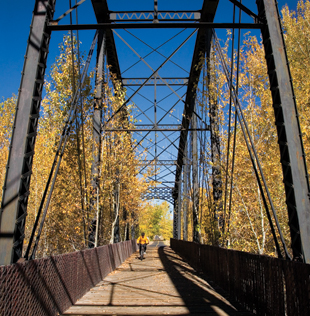
With the wind whistling through your hair and rails vibrating beneath your tires, cycling across the Cold Springs Bridge is surely one of the more impressive experiences the 32-mile-long Wood River Trail system has to offer.
Locally known as the bike path, the trail now has a purpose beyond its original conception as a multi-recreational use transportation corridor, and that is education.
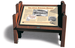
Pausing at the southern end of the bridge, users can see a small sign off to the right. One of a planned installation of 21 interpretive signs along the trail, the sign details the bridge’s history.
Developed by the Blaine County Recreation District, the Interpretive Signs Program provides information and stories about the valley’s colorful mining and ranching history, the railroad’s role in its development, and information on the geology, wetlands and native plants found along the path. Local historians, ranchers, old timers, librarians, botanists, geologists and the Idaho Department of Fish and Game contribute to the content and graphics on the signs.
The Interpretive Signs Program
is seeking sponsors for 11 additional signs. For information or to
dedicate a sign in the name of yourself or a loved one, contact the
Blaine County Recreation District office at (208) 788-2117.
Currently, eight signs can be viewed along the path. Two more signs are scheduled to go up this summer. Eleven more are in the design process, awaiting sponsors.
Click here to see a Map of the
Signs on the Trail
The sign at the Cold Springs Bridge reveals that the 217-foot single-span steel-truss bridge was engineered by George Pegram, and is one of only eight that remain in the country.
There were as many as 35 Pegram truss railroad bridges built in the late 19th century. Today seven of the eight remaining bridges are in Idaho, two in Blaine County: one at Cold Springs and the other six miles south of Ketchum below East Fork.
Pegram’s patented-design truss bridges were strong and transportable. Inexpensive to move and reassemble, the Pegrams were single-span bridges that used a minimum amount of metal to achieve proper strength. Web-like triangle construction allowed the bridges to support a variety of loads.
Built in 1884, the truss bridge at Cold Springs was originally used as a Snake River crossing in Ontario, Oregon. It was disassembled and brought to the Wood River Valley for the Oregon Short Line Railroad in 1917. In the early 1900s, lead and zinc were the main products transported by the railroad from the nearby mining regions. From 1936 until 1975, the Cold Springs Bridge also saw passengers roll through its trusses on their way to America’s first destination ski resort, Sun Valley.
By 1981, the era of rail service to the Wood River Valley had come to an end, and the railway right of way entered a period of rebirth—as a pedestrian and bicycle path linking the communities along the banks of the Big Wood River.
In 1984, the Blaine County Recreation District and the friends of the Wood River Trail system project (headed by locals Butch Harper, Bob Rosso and Mary Austin Crofts) began the process of transforming the unused line into a paved, non-motorized pathway. To date, nearly $4 million has been spent to construct this state-of-the-art trail system and add spurs linking Sun Valley, Elkhorn and East Fork to the system.
The Cold Springs Bridge is not the only historical stop along the trail. There are more than 20 points of interest along the way, including the East Fork Mines, the Arboretum, the Trestle Bridge and the Elkhorn Tram Line. The Interpretive Signs Program aims to reveal all of these historical and natural wonders. So, the next time you walk, bike or ski along the bike path, be sure to take a moment and reflect on the history beneath your feet.