

Photos by Todd Kaplan
Copper Basin
A secluded bastion of the Old West
Beyond the
rugged Pioneer Mountains, a remote valley is waiting to be
discovered.Text by Jason Kauffman. Photos by Todd Kaplan.
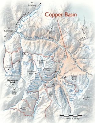
Just 25 magnificent air miles northeast of the Wood River Valley lies Copper Basin, a massive mountain valley set at an elevation between 7,500 and 8,000 feet. The wide-open spaces of the basin stand in stark contrast to the serrated peaks and hanging U-shaped valleys of the surrounding high country.
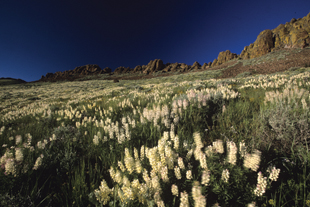
Roughly triangular in shape, the central core of Copper Basin is an approximately 20,000-acre expanse of rolling sagebrush steppe, drained by the East Fork of the Big Lost River, Star Hope Creek, and numerous other named and unnamed waterways. Prairie potholes and erratic boulders near the valley’s heart are a reminder of the earth-shaping glaciers that once covered all of this land.
Immediately surrounding the lower Copper Basin, rolling hills and narrow ridges, speckled with isolated aspen groves and narrow bands of north-facing timber, begin their long march skyward. High above, the ragged crests of the Pioneer and White Knob mountain ranges hem in this most western of landscapes.
Lording over it all, remote alpine summits—with names like Big Black Dome, Standhope Peak, Copper Basin Knob, Redbird Mountain and Porphyry Peak—cast lengthy shadows over a panorama largely free of outside human influence.
Tucked deep within this sea of ruggedness, Copper Basin is a gentle oasis for many species of wildlife. Unchallenged in their fast-paced supremacy, pronghorn antelope race across the lower sagebrush flats and high into upper elevation grasslands. Elsewhere, mule deer browse across the brushy patches on surrounding hillsides, while elk graze the edges between grassland and forest.
Along willow-lined streams and rivers, moose follow seasonal patterns up and down the region’s meandering waterways. Below the waterline, cutthroat, rainbow and brook trout swim alongside mountain whitefish in the clear, cold waters.
At the top of the animal food chain, cougar, wolf and coyote search for prey in relative obscurity. So rich is Copper Basin’s prey base that since wolves were reintroduced into Idaho in 1995 several packs have made the area their home.
The remoteness of the basin, however, hasn’t precluded it from controversy. In several instances, the mere presence of wolves has been an issue, most notably for several ranchers whose cattle graze the valley. After wolves from the Copper Basin pack killed a number of cattle in 2005, officers with USDA Wildlife Services exterminated most of them.
Cattle grazing along Copper Basin waterways have also caused heartburn. Critics of grazing in the area point to the churned soil in the basin’s wetland areas as a sign the bovines are too harsh on its delicate landscape.
Revel in a slice of true Idaho
For Pocatello resident and Idaho State University political science professor Ralph Maughan, Copper Basin and the high rocky peaks that surround it bring to mind another classic mountain valley. He sees Copper Basin’s wide open sagebrush flats, winding, willow-lined streams and surrounding high peaks as reminiscent of Lamar Valley in Yellowstone National Park.
In Idaho, the Sawtooth Valley and Stanley Basin are the only valleys that can remotely compare to Copper Basin, says Maughan, who knows his stuff, being the author of the guidebook Hiking Idaho and The Idaho Wildlands Web site. Throughout the state’s geologically rich central core, which Maughan describes as "all mountains and canyons," wide-open valleys like these are rare. In terms of its unspoiled nature, Copper Basin stands head and shoulders above all other Idaho mountain valleys, said Maughan. "It’s really undiscovered," he said.
Maughan viewed Copper Basin for the first time in the 1970s. Cresting the Corral Creek Summit, the new Idaho arrival looked around in astonishment at a complete 360-degree panorama of mountains. Tucked into that mountainscape was Copper Basin. Right then and there, Maughan reconsidered his notion that he’d be staying in Idaho only temporarily. "I remember thinking, ‘I want to stay here forever.’"
Something for everyone
For the outdoor recreationist, Copper Basin is a delectable territory of wide-open vistas and unconfined spaces. Unlike in the Wood River Valley, where steep hills confine the view, Copper Basin’s expansiveness is more reminiscent of Montana’s Big Sky Country.
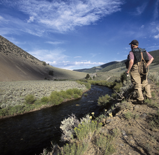
Here, local fly-fishing enthusiasts can enjoy a scene far different from their homewaters on the Big Wood River and Silver Creek, said Dave Faltings, the head guide coordinator for Silver Creek Outfitters in Ketchum. Copper Basin is one of the few local destinations where fishermen can pursue three species of trout along the same stretch of water, Faltings said. The meandering watercourses of the East Fork of the Big Lost River and Star Hope Creek can be fished on a warm summer day wearing nothing but shorts and sandals. These streams provide the perfect mixture of pools, pocket water, riffles and runs.
While Copper Basin’s waterways make it an obvious destination for local anglers and guided fishermen alike, it is the vale’s frontier-like feel and quiet solitude, maintained to some degree by the pains one must take to reach it, that are its most precious gems. One doesn’t reach this oasis by accident. "It’s out of the way," said Faltings. "You’ve got to struggle to get there."
Driving to Copper Basin is an experience in itself. Only four backcountry roads reach the remote valley. From Sun Valley, the shortest route into Copper Basin follows the rough gravel road up and over Trail Creek Summit and past Wildhorse Creek before finally breaking out into the northwest corner of the valley. Further east in the Lost River Valley, Copper Basin is accessible by way of three different roads, north and south of Mackay: along the Big Lost River, over the Corral Creek Summit on Burma Road and across the scenic Antelope Pass.
Once inside Copper Basin, a single loop road circles the outer perimeter of the valley. Radiating outward from the rough dirt road, a number of primitive side roads dead-end in isolated upper canyons of the Pioneer and White Knob mountains.
While certainly a remote destination itself, Copper Basin is also a great jumping-off point for even more uncrowded regions beyond. Surrounding the valley’s western horizon on two of its three sides are the roadless Pioneer Mountains. Worthwhile destinations in the Pioneer Mountains reached from Copper Basin trailheads include the upper headwaters of the Little Wood River, picturesque Muldoon Canyon and Idaho’s highest alpine lake, 10,438-foot Goat Lake.
Lying northeast of Copper Basin in the Pioneer Mountains’ far-reaching rain shadow, the White Knob Mountains are one of the most overlooked corners of Idaho high country. This is a high, wild region of very little timber and even fewer people.
Copper Basin is truly at its best in the hour between the sun setting and darkness falling. Viewed from up high on one of its western slopes, dusk advances across the valley’s undulating, sage-covered expanse at an almost imperceptible pace.
Looking east with the dwindling sun sinking in the west, the distant White Knob Mountains are bathed in brilliant shades of red and purple. Lower down, shadows finally overcome the last fading rays of daylight as Copper Basin is put to bed.
Directions from Ketchum
Four-wheel drive is recommended. Drive northeast on Sun Valley Road until it turns into the maintained dirt road, Trail Creek Road. Continue along this mountain pass for 22 miles. Where the East Fork of the Big Lost River enters from the east, turn right and head upstream going southeast. Following signs for Copper Basin, drive another 18 miles to the intersection with the Copper Basin Loop Road. Allow two hours each way.