| click here for the |
| front page |
| features |
| stanley, idaho |
| bronc riding |
| broadford riot 1885 |
| fighting fires |
| arts |
| three jewelers |
| custom saddles |
| living |
| kitchen design |
| pilates |
| recreation |
| white water fun |
| sporting clays |
| names of the peaks |
| summer trails |
| summer a to z |
| dining |
| seafood in the mtns |
| calendar |
| summer 2002 |
| listings |
| galleries |
| outfitters & guides |
| fitness |
| tennis |
| golf |
| property mgmnt. |
| lodging |
| dining |
| maps |
| ketchum+sun valley |
| summer trails |
| KART bus map |
| the guide |
| last winter |
| advertising |
| about us |
| copyright |
| Copyright
© 2002 Express Publishing Inc. All Rights reserved. Reproduction in whole or in part in any form or medium without express written permission of Express Publishing Inc. is strictly prohibited. |
| Produced
& Maintained by Express Publishing, Box 1013, Ketchum, ID 83340-1013 208.726.0719 Voice 208.726.2329 Fax info@svguide.com |
| The Sun Valley Guide is distributed free twice yearly to residents and guests throughout the Sun Valley, Idaho resort area communities. Subscribers to the Idaho Mountain Express will receive the Sun Valley Guide inserted into the paid edition of the newspaper. |

Where
the Asphalt Ends
Three
great trails to explore this summer
by Greg Stahl
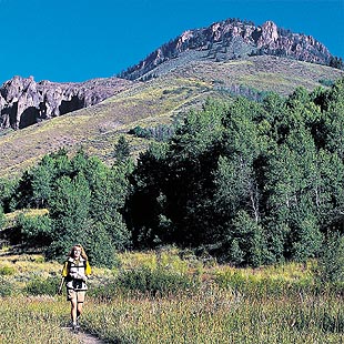
An intricate and varied web of trails braids the Sun Valley region. Paths weave through high mountain passes and roll through shimmering aspen groves.
They link glacial lakes and mountain peaks to wildflower meadows and majestic timber stands.
They connect wildlife sanctuaries to blue ribbon trout streams and ghost towns to Central Idaho’s population bases.
There are as many reasons to take to the trails as there are people who enjoy backcountry endeavors. Fortunately, the Sun Valley area offers ample selection for even the most obscure motivations.
The immediate Sun Valley backcountry contains close to 1,100 miles of maintained trails, all of which are part of the Sawtooth National Forest.
So, whether you want to stroll in a field of lupine, or enjoy panorama views, or explore the mountains on two wheels, the following list has you covered. Get out there. The Sun Valley backcountry is waiting.
Flower power
Adams Gulch Trails
Much of Central Idaho blooms in a myriad of wildflower varieties every spring and summer, but the Smoky Mountains, immediately west of Sun Valley, combine easy access with a consistent display of colors.
One of the most accessible trail systems in the region is just outside Ketchum in the Smoky foothills. For hikers, bikers and trail runners, Adams Gulch, Oregon Gulch and Fox Creek loops can be combined.
Rolling aspen groves, wildflower meadows, tight lodgepole forests and ridgetop-to-valley descents await.
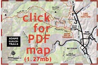 Adams Gulch, the closest to town, is just north of Ketchum. Go north on State Highway 75 past the stoplight at Saddle Road to Adams Gulch Road (1.5 miles from Ketchum). Turn left on Adams Gulch Road. A quarter-mile past the Big Wood River bridge, the road bends left, uphill, and through an archway with a private property sign. Continue on the road, which is available for public access, to the trailhead.
The loops range from two to eight miles.
In the thin air
Hiking in the Sawtooths
Observation Peak in the Sawtooth Mountains is a strenuous 16.6 mile round-trip with 2,614 feet of elevation gain, but the summit lives up to its name.
“After an all-day trek to Observation Peak, you’ll revel in a panorama usually seen only by climbers or pilots,” writes Lynne Stone in her book, “Idaho’s Sawtooth Country.”
Drive to Stanley Lake five miles west of Stanley on State Highway 21, turn left on Stanley Lake Road 455. Go three miles to the Stanley Lake Creek trailhead, where the trek begins amidst lush meadows with stunning views of McGowen Peak (9,860 feet), the northernmost peak in the Sawtooth Wilderness Area.
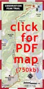 Lady Face and Bridal Veil water falls are about three miles along the route and can make for easier alternatives to Observation’s stunning views. After the valley view of Bridal Veil Falls, continue beside Stanley Lake Creek, passing at 6.2 miles a road to the old Greenback mine.
After another 0.8 mile, reach a three-way junction. Observation Peak is 1.3 miles and 1,119 feet above to the west.
Pedal pushers
Mountain biking in the valley
Five mountain bike rides begin from the Greenhorn Gulch trailhead, all of which are quite enjoyable. But Lodgepole Gulch has a sort of solitary beauty about it like none of the others.
Deer, fox, elk and the occasional black bear are not uncommon on the trail.
 After winding up through the forest for five miles, the top of the loop offers impressive views of the Pioneer Mountains to the east and of the back side of Bald Mountain. This is the beginning of a long and enjoyable descent into Mahoney Creek and back to the trailhead for a total loop of 10.9 miles.
To reach the Greenhorn Gulch trailhead, drive six miles south of Ketchum on State Highway 75 and turn west on Greenhorn Gulch Road. Continue for another 3.8 miles to the trailhead parking area. •
Background topographical maps are from the National Geographic “Topo” series for the state of Idaho, and are reproduced here with the permission of National Geographic. The CD-ROM set is available for around $100 at sporting goods stores throughout the valley.