|
|


|
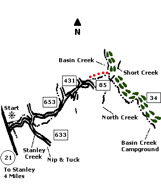
 Map |
 |
 Summary |
| ABOUT
THE RIDE: This scenic ride in the
Stanley Basin gives you great views of the
Sawtooths. It also takes you through history, as
you ride past a mining camp built in 1887. The
ride combines dirt roads and trails into a ride
best done with a shuttle. There is also a creek
crossing that can be challenging in the early
summer. GETTING THERE: Drive to Stanley, then turn left (west) onto Highway 21. Drive to the junction of Stanley Lake\Nip and Tuck access road on the north side of the highway. It's just past MM #126, four miles west of Stanley. Park your car. To do the ride as a shuttle, park another car at the Basin Creek Campground, on State Highway 75, five miles north of Stanley. THE RIDE: Follow the road east for 1.4 miles until you come to a crossroads marked by a large Forest Service direction sign. Turn left (north) at this point and follow the road for one-quarter mile until you come to a fork in the road just past a cattle crossing . Turn right (east) at this fork and follow this road for the next 3.1 miles. It is designated by the Forest Service as road #653. There are great views on this section. At 4.5 miles into the ride, you'll come to another fork, with a sign saying " Stanley Creek Road" and "Kelly Creek Road". Bear right (NE), following the Kelly Creek Road. There is a three-quarter mile uphill grade here. When you crest the hill and start down, watch for historic sites along the way, including a mining camp built in 1887. The road continues for approximately one mile, then bottoms out at a bridge 7 miles into the ride. Take a sharp right onto the trail leading up a steep grade. Straight ahead, watch for the trail following the creek down the valley. The trail winds 1.2 miles down the Kelly Creek Valley, ending at Basin Creek. It can be in poor condition and crosses the creek many times. Watch for deer. Cross Basin Creek carefully. It can be large and swift in late spring and early summer. After crossing, turn right (south) on the jeep road. This brings you back to the scenic Basin Creek Valley. It is a leisurely, downhill grade for 4.5 miles, ending at the Basin Creek Campground on State Highway 75. |
|


© 1997 JHL
& Associates, all rights reserved ~ Produced
by JHL & Associates |