|
|


|
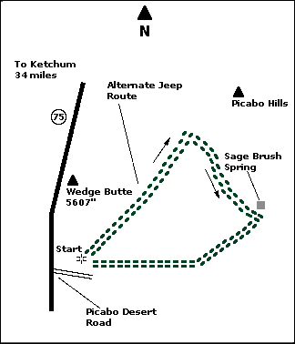
 Map |
 |
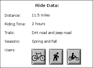
 Summary |
| ABOUT
THE RIDE: This is a desert ride on
Bureau of Land Management (BLM) property that can
be enjoyed as early as late March, at least a
month before the trails in the upper Wood River
Valley open. Rolling hills and crosswinds make
this easy ride interesting. The desert flowers
can be beautiful between mid-April and mid-May.
Sonners Reservoir is a good place for bird
watching as the spring migrants pass through. You
might also see elk, mule deer, antelope and
several raptor (hawk) species. This ride gets hot
and dusty in the summer with no shady areas, so
bring plenty of sunscreen and water. After heavy
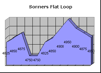
rains, the mud can be thick as gumbo soup. GETTING THERE: Drive 34 miles south on State Highway 75 from Ketchum, and turn east (left) on the Picabo Desert Road. This ride is south of Timmerman Crossing and Wedge Butte. Drive .8 miles from the highway to an unloading area at an old quarry. This is where the ride begins and ends. THE RIDE: The ride is in the shape of a triangle and is easy to follow. All of the prominent local landmarks are visible throughout the ride, and the route is well signed. It is best to have a tail wind or at least a side wind on the return to the quarry. Before you start, determine the wind direction. The wind usually comes from the southwest, but it can blow from the east on sunny, spring days. Assuming there is a southwest wind, ride north from the quarry, around Wedge Butte. The ride will merge with a pipeline road after one-half mile. Follow the pipeline road down a long, gradual hill for about three miles. Make a sharp right turn to the south at the base of Picabo Hills. Follow this road for three miles to Sagebrush Springs which offers the best view of the desert expanse to the south. On a clear day, you can see past Shoshone to the Elkhorn Mountains in Nevada. At Sagebrush Springs, turn right (west). You will pass by the dam at Sonners Reservoir, which may be too mucky for swimming. This is an exceptional spot for bird watching. Stay on the main road, which returns to the quarry or to State Highway 75. |
|
© 1997 JHL
& Associates, all rights reserved ~ Produced
by JHL & Associates |