|
|


|
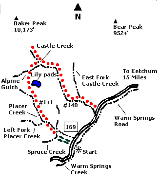
 Map |
 |
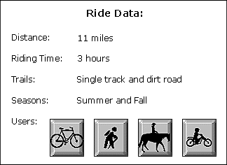
 Summary |
| ABOUT
THE RIDE: This ride is worth doing just
to see the destruction caused by the Baker Peak
avalanche. The descent from the lily pads to the
avalanche path is for experts only. Other
sections require pushing your bike. Good
pathfinding skills are required in the avalanche
debris where there are great views of Baker Peak
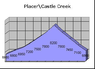
and other areas. GETTING THERE: Drive out Warm Springs Road 15 miles to Placer Creek, five miles past Frenchman’s Bend Hot Springs. Park at the sheep corrals in a meadow on the right side of the road. THE RIDE: Follow the dirt road leading to the right (north) up Placer Creek Trail for approximately two miles. Less than one-quarter of a mile past the second creek crossing, look for a post sticking up on the right, just past where the road turns to single track. The post is not prominent, so look carefully. Take the right fork at the post. The other trail is called Left Fork, it looks more prominent, but dead ends. You can take this trail as an "out and back" with great views of Baker Peak to the north. Follow the trail down into a small creek and up the other bank, paralleling the creek in tall grass. At this point you will begin a gentle climb and an intermittent "hike & bike" through two rocky sections. At times the trail is obscured by tall grass. Eventually you will come to a meadow of wet lands and lily pads. Do not take the trail that climbs to the right of the lily pads - it dead ends. Skirt around the right side of the lily pads, then cross to the left side (which is dryer). At the top of the lily pads, the trail crosses two meadows. One-quarter mile past the meadows, you will reach the top of this ascent. From here, be ready for a quick 1/2 mile descent into trees with sharp switchbacks. After crossing two rushing streams, you will come to a clearing. The trail is hidden by the avalanche debris, so look carefully. It becomes defined again on the far left side and at the bottom of the drainage. In less than one mile you will "t" into the Castle Creek Trail. Turn right, then wade across Castle Creek, removing your shoes to keep them dry. From Castle Creek to Warm Springs Road, it is a four mile rolling descent. Prepare for downed trees and shale piles. It’s single track all the way. At the bottom of Castle Creek, ford Warm Springs and return to Warm Springs Road. Ride back two miles to your car. |
|
© 1997 JHL
& Associates, all rights reserved ~ Produced
by JHL & Associates |