|
|


|
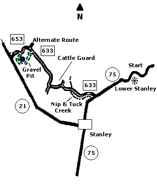
 Map |
 |
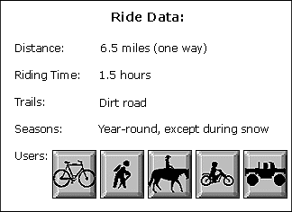
 Summary |
| ABOUT
THE RIDE: Nip and Tuck was named by the
old-time freight wagon drivers who traveled this
historic road. It is one of the Sawtooth's most
popular rides, offering unparalleled views of the
Sawtooths and White Clouds. It is easy riding on
dirt and jeep roads. During the winter, the trail
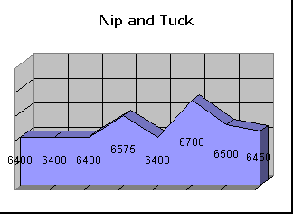
can be ridden when the snow is hard. GETTING THERE: Drive one mile past Stanley on State Highway 75 to Lower Stanley. Because the land at the start of the ride is private, park you car at the Ace of Diamonds Boat and River access, approximately one mile past town, at the confluence of Joe's Gulch and the Salmon River. To make it a one-way ride, leave a car at the Stanley Lake access. THE RIDE: From the parking site, ride back towards Lower Stanley and turn up Nip and Tuck Road. The road is gravel with good traction. At 3.5 miles you will come to the top of a drainage and cross over a cattle guard. From here there are great views of the historic Stanley Basin where gold was discovered in 1863. The next half mile is an easy downhill into the heart of the basin. Continue straight through the "Crossroads." Nip and Tuck Road ends at State Highway 21 across from the Stanley Lake access road. This is the confluence of Stanley Creek and Valley Creek and is a great place to stop for lunch or a rest before returning to Lower Stanley. For real thrills, ride this trail in the winter. It is groomed for snowmobiles and makes for excellent mountain biking. Watch out for snowmobiles not expecting mountain bikes. ALTERNATE ROUTES: 5.5 miles into the ride, turn left (south) onto a road that becomes a jeep road with spectacular views. Continue past a small gravel pit, keeping to the right until breaking into the open, where you will encounter more great views. There is a short, fun, descent back to Nip and Tuck Road. At this point, turn left (west) and follow the road to Stanley Creek. |
|
© 1997 JHL
& Associates, all rights reserved ~ Produced
by JHL & Associates |