|
|


|
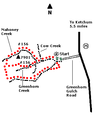
 Map |
 |
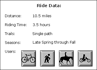
 Summary |
| ABOUT
THE RIDE: Greenhorn Gulch offers many
exhilarating rides. Advantages to this ride are
fewer users and the trail is well maintained. In
warmer weather, this ride is best done in the
morning or evening. GETTING THERE: Drive south from Ketchum on State Highway 75 for five and one-half miles. Turn right (west) onto Greenhorn Gulch Road (look for the "Golden Eagle Ranch" sign) and drive three and one-half miles. Park at the turnaround by the restrooms (just past the old fire guard station). Note: Greenhorn Gulch is a private road. Respect the home owners' rights by not speeding or driving on their property. Motorcycles are prohibited on this road. THE RIDE: From the parking lot, take the dirt road heading southwest up the canyon. Pass the gate, leaving it as you found it. Continue up the road one-half mile through two stream crossings (which may be dry) to the junction of Greenhorn and Mahoney Creeks. Take the right fork up (north) Mahoney Creek. The road turns into a trail that quickly steepens, rideable only by experts or by pushing your bike. After one and one-half miles, you come to Lodgepole\Mahoney Trail split. Take the left fork (southwest). You are on the correct trail if you come to a stream crossing within 100 yards of passing the junction. After crossing the stream, the trail climbs through trees. After one and one-half miles you will come to another intersection. Take the left fork (south). The trail traverses a ridge, then stays almost flat near a creek (usually dry). Climb for one-half mile up a steep hill that may require pushing your bike. Once on top, continue straight, avoiding the faint trail branching to the left. From here, the trail, known as "Bones Trail," is steep and downhill, taking you back into Greenhorn Gulch. For the next one and one-quarter miles, the trail descends quickly and may require dismounting. When you come to a four way intersection, take the left fork to return via Greenhorn Creek or continue straight for a longer ride, via Imperial Gulch. |
|
© 1997 JHL
& Associates, all rights reserved ~ Produced
by JHL & Associates |