|
|


|
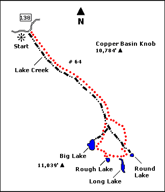
 Map |
 |
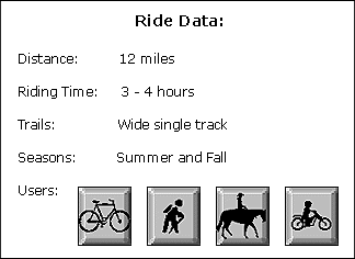
 Summary |
| ABOUT
THE RIDE: This Copper Basin ride takes
you into the heart of the Pioneer Mountains, and
past several high altitude alpine lakes. It is
also on an incredibly well-groomed trail, thanks
to the efforts of backcountry motorcycle riders.
So if you like this ride, thank them. Advanced
riders will have no problem climbing all but a
few sections, which are fun challenges for
beginning and intermediate riders. Because of the
high altitude of this ride (9600'), be prepared
for cool weather anytime. GETTING THERE: From Ketchum, drive out 20 miles on Sun Valley Road, over Trail Creek Summit, and turn right at the Copper Basin turnoff sign. Drive 2.2 miles, then turn left (east) onto Copper Basin Road, taking the bridge across the creek. Follow this road 16 miles (bypass the first Copper Basin Loop Road sign at 10.5 miles), and turn right at the second Copper Basin Loop Road sign. Drive 4.5 miles to the Lake Creek turnoff and park your car. THE RIDE: Ride up the trail starting from the parking area. This is a gradual uphill, winding through trees and a large meadow. You'll be treated to great views of the Pioneers. At 4 miles, take the left fork (near the old cabin). From here the trail steepens, and there are sections that might require pushing. Two miles past the fork, the trail passes Round Lake on your left. You can take a short hike to this lake, or continue on. Long Lake is 1/2 mile further on, and a great place to rest. There is a great location on the left side of the lake as you approach it. One mile and several rocky switchbacks further, the trail passes Rough Lake. After another mile of gradual uphill through meadows and small ponds, the trail reaches Big Lake, the largest of the lakes on the tour. This lake is surrounded by mountains and crags, and is also a great place to take a lunch break and go swimming. From Big Lake, it's a great 6 mile downhill back to the car, winding through trees, crossing well-maintained bridges, then rejoining the trail in the meadow. |
|

© 1997 JHL
& Associates, all rights reserved ~ Produced
by JHL & Associates |