|
|


|
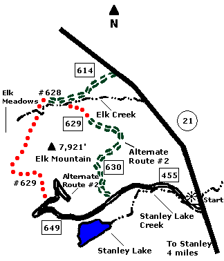
 Map |
 |
 Summary |
| ABOUT
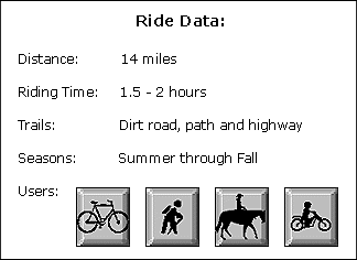
THE RIDE: This ride affords great views
of Stanley Lake, the Sawtooth Mountains and Elk
Meadows. In the evening, you might see elk, deer
and sandhill cranes in Elk Meadows. There is an
alternate route for more advanced riders and a
way to avoid the section which uses State Highway
21. GETTING THERE: Drive four miles west of Stanley on State Highway 21 to the "Stanley Lake Access Road" (just past mile marker 126). Turn left (south) and park. THE RIDE: Start by riding west on Stanley Lake Road. During the summer, be prepared for automobile traffic to and from Stanley Lake. At three and one-half miles from State Highway 75, turn north on Forest Service Road #649 at the cattle guard, then ride uphill to the "Elk Creek Loop Trail" trailhead (also marked USFS Road #629). Turn left (north) at the Elk Meadows trailhead and sign-in at the box. The trail will be firm but rocky for one and one-half miles with a descent into Elk Meadows. This is a great place to rest. Turn right (north) at the sign marked "Lower Elk Creek Loop". For the next two miles, the path winds downhill in and out of the forest until you come to Elk Creek. Proceed across the creek, past another sign-in box and continue to a jeep trail. Follow this trail back east to State Highway 21. Turn right (southeast) and follow it for three and one-half miles back to your car. ALTERNATE ROUTE #1: To avoid using the State Highway for your return, look for a sign marked "Lower Elk Creek Loop" approximately one mile after connecting with the jeep road. You must cross the creek again and proceed south on a network of old double track logging roads. One-half mile past a large park with great views of the Sawtooths, take the right fork (west) at the bottom of a small hill. From this point it is a rolling ride back to Stanley Lake Road and your car. ALTERNATE ROUTE #2: Advanced riders may continue for two miles on the road to the top of Elk Mountain. This is a good steep workout for intermediate and advanced riders. Follow the "Sawtooth Scenic View" signs. The views are great on top. |
|
© 1997 JHL
& Associates, all rights reserved ~ Produced
by JHL & Associates |