|
|


|
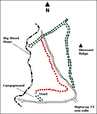
 Map |
 |
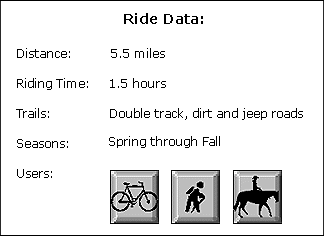
 Summary |
| ABOUT THE RIDE: This is a
short ride with a lot of variety. It runs along the Big Wood River Canyon below Magic Dam.
This three mile section of the Big Wood is full of birds and fish. You can walk down into
the canyon for fishing, scenery, swimming or to look for the family of river otters which
live in this section of the river. The flowers can be impressive between mid-April and
mid-May. Portions of the ride follow the old railroad bed which used to run between
Shoshone and Fairfield. The bed ends abruptly at the former site of a major bridge. There
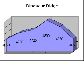
is an active golden eagle nest on top of Dinosaur Ridge, so eagles and fledglings are
frequently seen in this area. Antelope also reside in this area. This is a desert ride, so
be sure to bring lots of water and sunscreen. GETTING THERE: Drive 36 miles south of Ketchum on Highway 75. Turn west (right) at the Bureau of Land Management (BLM) sign to the "Upper Big Wood River Access." You can park just off the highway, but this ride begins and ends at the river access campground which is two and one-half miles from the highway. THE RIDE: You can ride the loop in either direction and its short enough that the wind will not be a major factor. Be aware however, of the wind if you decide to extend the loop or go for an excursion. We'll describe the ride in clockwise direction. Start at a gate near the north end of the BLM campground. Please keep the gate closed regardless of how you found it. An old, little used two-track trail runs north and then east along a low piece of rim rock for about a mile. When you see the old rail bed about you, stop and walk your bike up the hill and over the fence. Proceed left or west down the rail bed. If you prefer not to walk up the old embankment and don't like lifting your bike over fences, you can stay on the two-track until it joins the Magic Dam road which parallels the rail bed. After a mile, and just before the rail bed disappears over the cliff, turn right. Follow this road up the hill to the pass in Dinosaur Ridge. Go through the gate (leave this one like you found it), for a couple of hundred yards. Watch for a faint trail to the right and a mountain bike sign with an arrow. You now have a nice mile and a half downhill along the west side of Dinosaur Ridge. Follow the signs back to the campground at the junction with the Magic Dam Road. |
|
© 1997 JHL & Associates, all rights reserved ~
Produced by JHL & Associates |