|
|


|
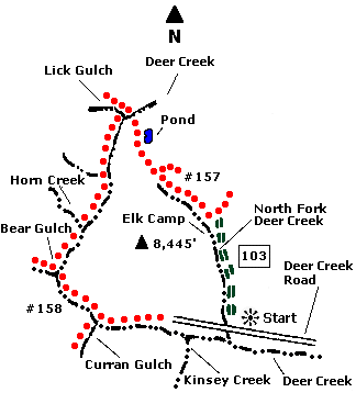
 Map |
 |
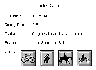
 Summary |
| ABOUT
THE RIDE: Part of this trail winds
through rocky creek beds, testing your bike
handling skills. There are also challenging
inclines that might require pushing your bike for
short distances. There is also a great rolling
descent, but watch for trail washouts and tricky
conditions on this part of the trail. The views
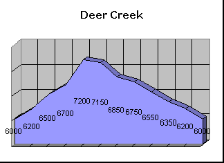
offered on this ride are limited. GETTING THERE: Drive south of Ketchum nine miles on State Highway 75 and turn right onto Deer Creek Road. Look for the National Forest access sign. The radio station KSKI is located on the east side of State Highway 75. Drive eight miles west on Deer Creek Road. Park near the sign marking "North Fork of Deer Creek." THE RIDE: From the parking area, ride the two track road 1.5 miles north to a prominent fork. Take the left fork (west). From here, the road turns into a steep trail. The next two miles will be uphill through the trees, with certain sections requiring a push of the bike. You will come to an elk camp at the top of the hill, a great place to rest. Just past the elk camp, you will come to a prominent fork in the trail, take the left fork. The trail gets rocky at this point, but is still rideable. The trail will be flanked by trees and then sagebrush. Next the trail heads downhill crossing two small creeks. After a fast descent through some woods, the trail comes out on a southern exposure. It winds through sagebrush, eventually crossing Sullivan Creek, coming upon a trail intersection. Turn left (south) at the intersection. The trail rolls downhill next to a creek in a small canyon. The trail is technically demanding and rocky. There are a number of big rocks that you can ride up and over. Short stretches of the trail may require the pushing of your bike. Eventually you will come upon a sign marked "Bear Gulch" to the right (west). Turn left, away from Bear Gulch, on a long rolling downhill pitch that takes you past the Curran Gulch Cairn. The trail comes out at the Deer Creek Corrals. Continue east on Deer Creek Road to your car. |
|
© 1997 JHL
& Associates, all rights reserved ~ Produced
by JHL & Associates |