|
|


|
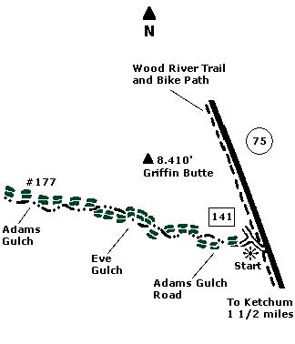
 Map |
 |
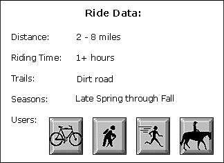
 Summary |
| ABOUT
THE RIDE: This is a perfect ride for
families, groups of varying ability or anybody
that wants to take an easy scenic ride. The ride
can be as short or as long as you want. The
farther you travel, the more demanding the trail
gets. There are several fun stream crossings that
you can either ride through or take log bridges
over. The views of Adams Gulch change
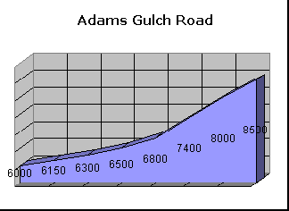
dramatically with the position of the sun. GETTING THERE: Drive north on State Highway 75, one and one-half miles from Ketchum. Turn left on Adams Gulch Road (look for the "National Forest Access" sign). Cross the bridge over the Wood River and turn right at the "T" intersection. Drive 300 yards and turn left up Adams Gulch (look for a log arch over the road). Drive one-half mile and look for the parking area (one-quarter mile past the Sawtooth National Forest Boundary sign). This ride is also accessible by riding north on the Wood River Bike Path and Trail System. THE RIDE: Start by riding up the dirt road. You will come to several stream crossings along the way - all are rideable. Try them, all you can do is get your feet wet. If necessary, there are log bridges you can take instead. At two and one-half miles, the road splits. One option is to head up the left fork, called Eve's Gulch. This trail lasts for one and one-half miles and eventually becomes too steep to ride, forcing you to push your bike over the crest. The trail ends at Warm Springs Road (consult local bike shops for more information). For easier riding, take the right fork up Adams Gulch, which has several more stream crossings. One-quarter mile from the fork will be the turnoff for Adams Gulch Loop. The trail is marked by a rock cairn and a sign that says "Adams Gulch Loop." Continue for another one-half mile. At this point, the road becomes single track. The farther you head up this trail, the more demanding it becomes. The trail gets steeper, crosses shale rock piles and is more challenging than the beginning section. If there are people in your group wanting a more strenuous ride, let them break ahead. Since they must return using the same road, you can regroup on the way back. |
|
© 1997 JHL
& Associates, all rights reserved ~ Produced
by JHL & Associates |